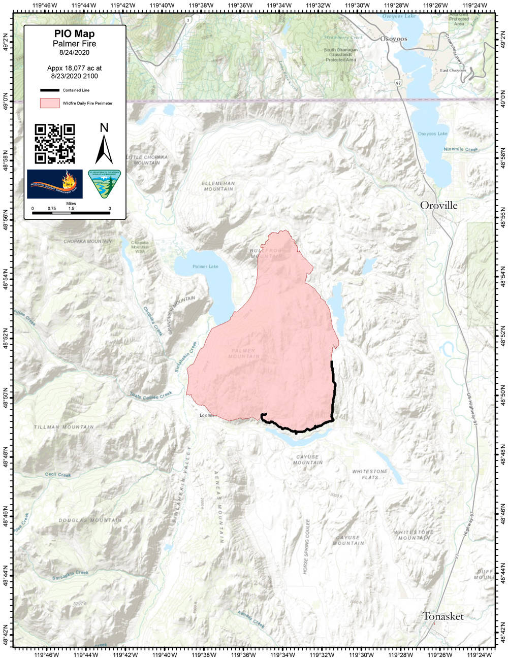
OROVILLE – Firefighters made significant progress yesterday fighting the Palmer Fire and containment of the 18,077 acre fire is now at 27 percent, according to the Monday, Aug. 24 update from Northwest Incident Management Team 6.
“Burn-out operations continued in the vicinity of Loomis. Air tankers dropped retardant north of town helping to further secure the area. Burn-outs using aerial ignition also took place on the northern perimeter of the fire near Bull Frog Mountain,” says the report.
Team liaisons and incident commanders have worked with ranchers to preserve the integrity
of grazing lands while aggressively fighting the fire. For the next few days, the focus will shift to mop-up and securing a 300 foot radius around structures in the fire area.
A virtual public meeting will be held on Tuesday, August 25th at 6 p.m. to 6:45 p.m. on the Okanogan County Emergency Management Facebook live. The meeting will include short
presentations from the Incident Management Team and the opportunity to ask questions. Questions can be submitted in advance to 2020.palmer@firenet.gov.
The cause of the fire is still listed as unknown. It is located east of Palmer Lake and northeast of Loomis, west of Highway 97. There are 517 personnel assigned to the fire. These include two Type 1 Crews, eight Type 2 Crews and six aircraft, as well as 58 engines, 18 water tenders and nine dozers.
All previous evacuation levels remain in place.
Level 3 Evacuations – GO! (evacuate now, leave immediately):
- Wannacut Lake Road (East) from Washburn to Ellemeham Mtn. Rd.
- Toats Coulee Rd. to Chopaka Rd., along the Loomis-Oroville Rd.
Level 2 Evacuations – SET (be set to evacuate):
- Ellemeham Mtn Road from Ellis Barns Road to Loomis-Oroville Road
- Town of Loomis
Okanogan County Emergency Management and the Okanogan County Sheriff’s Department are coordinating with fire personnel regularly to assess the status of evacuation levels. The public is asked to help fire personnel by obeying all road and Level 3 evacuation area closures for their safety and the safety of those working in the region.
The following roads are closed:
- Wannacut Lake Road at Ellemeham Mtn. Rd.
- Blue Lake Rd. at Lake Front Rd.
- Washburn Lake Rd. at Loomis-Oroville Rd.
- Ellemeham Mtn. Rd. to Ellis Barnes Rd.
- Loomis-Oroville Rd. to Toats Coulee to Chopaka Rd.
Those that have been evacuated are encouraged to contact the American Red Cross at 509-670-5331 for assistance. For information on livestock evacuations, contact Roger Sawyer at 509-429-8036.
Public use restrictions are in affect and all campfires and shooting of firearms are prohibited. Please visit: https://gacc.nifc.gov/nwcc/districts/NEWICC/index.html
For further fire information call 509-906-8801 from 7:30 a.m. to 8 p.m.


